EXCLUSIVE: Foxy Island may contain an undiscovered Barrow, here’s the evidence
Summary: An extensive study of 19th century maps and use of LIDAR technology unveils something undiscovered about “Foxy Island” that fits in with the local historic pattern of hills being used as neolithic burials and monuments.
Foxy Island is the colloquial name for the open space of land sandwiched between Farringdon, Gilley Law, Silksworth and Doxford Park. An undeveloped wilderness, it is a popular place for people to walk and take their dogs, having been given this name because it has no recorded official name, although its southern portion facing Silksworth Road is called “Foxhole Wood.” It is believed to be part of the Silksworth estate accordingly, although finding this land on the HM land registry has been difficult.

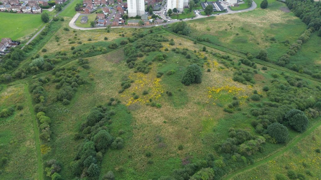
Drone photos taken of Foxy Island in August 2024 by SGM
As the author of piece, I have grew up with this piece of land and the stream that runs through it, the Hendon Burn. First, and most unfavourably, it is remembered as the site of the dreaded Farringdon School cross country run. Then, more favourably, we would always go to visit my Aunty in Gilley Law. Sometimes, youths would even set the fields on fire. Foxy Island was adventurous, if not a bit intimidating due to its association with such anti-social behaviour. Even today, it is subjected to the infamous “motorcycle disorder” of youths, and the tire marks and circles, not Celtic circles before we get into it, are visible on Google Maps.
In 1998, Sunderland City Council initially envisioned to transform the area of Foxy Island into a country park, but these plans never materialised. Then, in 2021, plans were proposed to build a crematorium on it. These plans were thankfully beaten back with overwhelming opposition, because who wants to look at that of their window out of Gilley Law flats every single day? Although the plans were withdrawn, I have continued to experience anxiety that the local authority will ultimately eye an opportunity to build on it one way or another. To its right hand side on Silksworth Lane after all, a housing estate has already been built on the hill above, which saw a small portion of trees cut there down to build a clearing.
Because of this, I have been proactive in studying the area of Foxy Island for the following three years in the view to maintain and further its use for the community. Key to this effort has been the mammoth task of attempting to unravel the history of the space, which of course is very challenging because you are conducting research into a piece of land of which no official name exists bar a modern era colloquialism, and therefore no direct or searchable record of any buildings or usage on it exists. In the modern era, absolutely nothing has been built on Foxy Island. As a result, all research that can be conducted has to be primary, meaning we have to uncover evidence directly than using recorded sources.
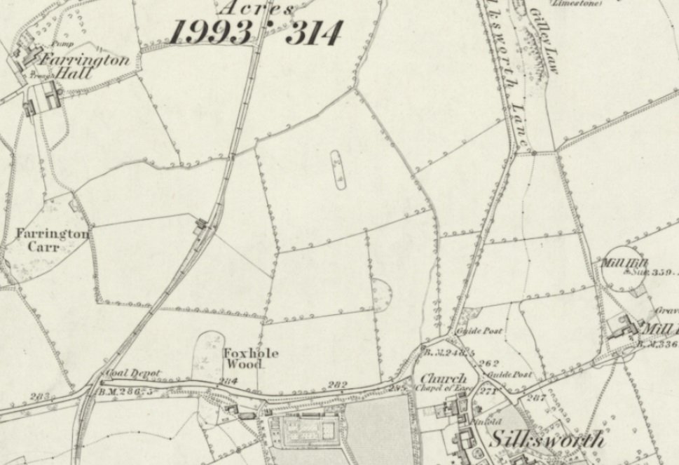
My first port of call has been to search maps of Sunderland of the area from the 1700s and 1800s. These maps provide interesting viewing and through them I have learnt the history of many other parts of Sunderland and observed how they have changed. I have given particular focus to the 1856 ONS map of the area because it is the earliest map available that shows the area up to modern, professional standard and allows you to inspect land in detail. Any map further map back will show a blank space between Silksworth Road and Silksworth Lane, which can tell you nothing was built there, but that’s about it. Essentially the further back you go, the less sophisticated and detailed maps get.
As the above paragraph shows, the land of “Foxy Island” has therefore been remarkably consistent for perhaps 200 years or so, being locked into the same diamond shape marked by tracks which was only demarcated from Farringdon with the construction of the Hetton Colliery Railway, the remnant of which is the footpath today. Of course, the land is a bit larger as Gilley Law’s village does not yet exist, and it runs into there too, but ultimately we don’t have that space to work with anymore (which is all the more important we salvage this).
As the 1856 map eludes, there was also an additional stream that no longer exists, the Farringdon Burn, which runs from the “Farrington Carr” (now school) swamp downhill into the Hendon Burn. The remnants of this route are still visible today and there appears to have been an undercutting where it was funnelled underneath the Hetton Line. When the swamp was drained and Farringdon School was built, the Farringdon Burn subsequently disappeared. But anyway, moving on, it may appear on surface value that this still somewhat blank map doesn’t tell us a great deal about “Foxy Island” on first glance, or does it?
After staring at this map frustratingly on and off over the years, it eventually came to my attention that in the centre of the diamond patch at the very summit, the map maker ringed off a circle of trees. The ring is merely annotative than existing in reality, showing divisions between land but also marking features in the land, such as small embankments, mounds, trees and places unsuitable for agriculture. This immediately indicates there is a distinguishing feature at the summit of “Foxy Island” which of course, has not changed today with a grouping of trees at the top. This group of trees appears to have been distinct from the “open land” for whatever reason. Further down the map as you can see, another semi-circle to the south has also been drawn on it. Why are these here?
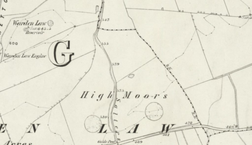
If we then cross compare these annotations with other unusual tree filled lumps and mounds in the local area sitting in fields, of which are known to be historic Barrows, we see the map treats them in a remarkably similar way. Here for example, is the area around Warden Law off Hangman’s Lane, where two barrows exist to the left and right of the road. Another example not shown here, is the Barrow in Thorney Close known popularly as “the newty”, although its markings on the 1856 map are different as was a swamp then as it is today. Yet, you get the point, we are seeing the presence of “enclaves” inside of land that are unique or distinctive features. Many of these are prehistoric barrows.
But of course distinctive features on a map are not enough to prove this alone, but there is more. Around 2022, I spoke to an archaeological company called AAG archaeology. My reason for contacting them was in fact about this area, as the firm had been hired to do surveys on behalf of the new primary school that was built opposite Foxy Island on the other side of Silksworth Road (again, we see land being carved up). His research dived into the geological and prehistoric use of this wider area round Doxford Park, having sent me his study.
Here, he laid out research that the area around the Farrington Carr (school), and thus by extension Foxy Island being right next to it, may have been a site of “prehistoric activity.” He notes on that particular survey that the origin and usage of the Foxy Island land is otherwise, unknown, commenting that it may have been part of the Farringdon Hall estate. It may also have been a “hunting park,” with hunts there continuing in the early 20th century.
However, we are going to focus primarily on the prehistoric (defined as Pre-Roman Britain) angle, where we have now secured a lead. Having looked at 1856 maps, the next method of study I pursued was the use of LIDAR (light detection and ranging) maps to explore the specific details of the land. LIDAR is used by archaeologists to essentially map the entire shape of land, bypassing trees and grass. It has been used to make many historical discoveries, whether it be a Viking Longship in Norway recently, or a lost ancient city in the Amazon. LIDAR is one of the most powerful archaeological analytical tools, and as it happens we have full LIDAR scans of Sunderland and County Durham in the public domain at our fingertips. Thus, I used LIDAR to assess Foxy Island. This is what it looks like:
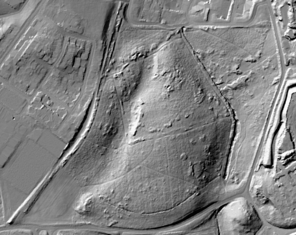
Now, when you use LIDAR you have to understand what you are looking at, and you also have to think objectively and theoretically about each and every little detail. Youths have also made a nuisance of this study as the imprints of their bike tracks also show up on it. But otherwise, what we are looking at? First of all, at the bottom of the map, you can see remnants of a medieval farming (Ridge & Furrow) system in the football field. This is also present in the crescent area bordering Silksworth Road which is now covered in trees, which has made it fade significantly over time.
The main area of Foxy Island, however, does not appear to contain this Medieval marking. There are some very faded lines showing the land was once ploughed and cared for, but this doesn’t correlate with the explicit ridge and furrow lines seen in documented Medieval farm sites such as Herrington’s West Park, Backhouse Park or Barnes Park, all which can be seen on LIDAR. However, if you look near the bottom right hand corner of Foxy Island (which is where the location of the semicircle cut off in the 1856 map is), you do see a square shaped deep incision in the ground. This area is completely covered by trees. There may have been a building here, with LIDAR revealing in open areas the foundation cuts of buildings which previously existed. If such a building existed, it predated the modern era. This pattern is also visible in the LIDAR results of villages that have been consistent in size since the Middle Ages, such as Burdon.
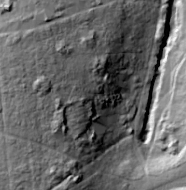
Moving on, if we go the summit of the Foxy Hill “diamond” formation in the middle of the map, which was marked off on the 1856 survey, we can see some incisions or small depressions in the ground around where the trees are.
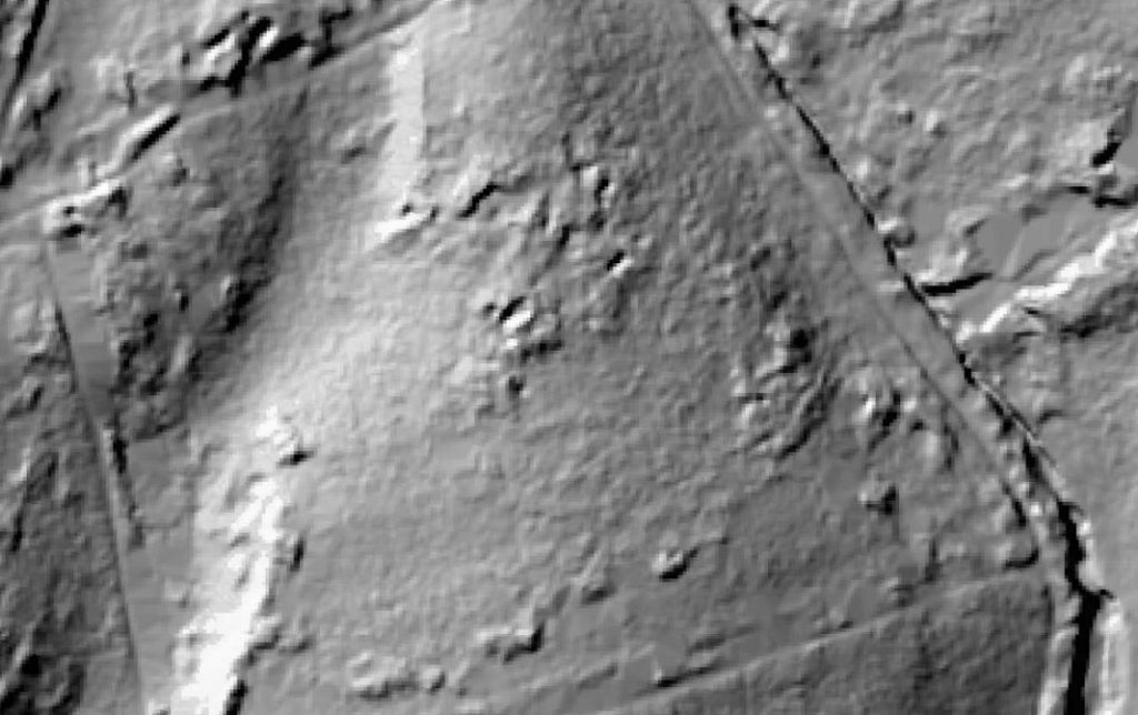
Similarly, further down the map nearby the location of the second cut off, there is a distinct circular mound which appears. It does not look natural because it is perfectly circular in shape, similar in nature to sites such as Seven Sisters. Could it be, a barrow?
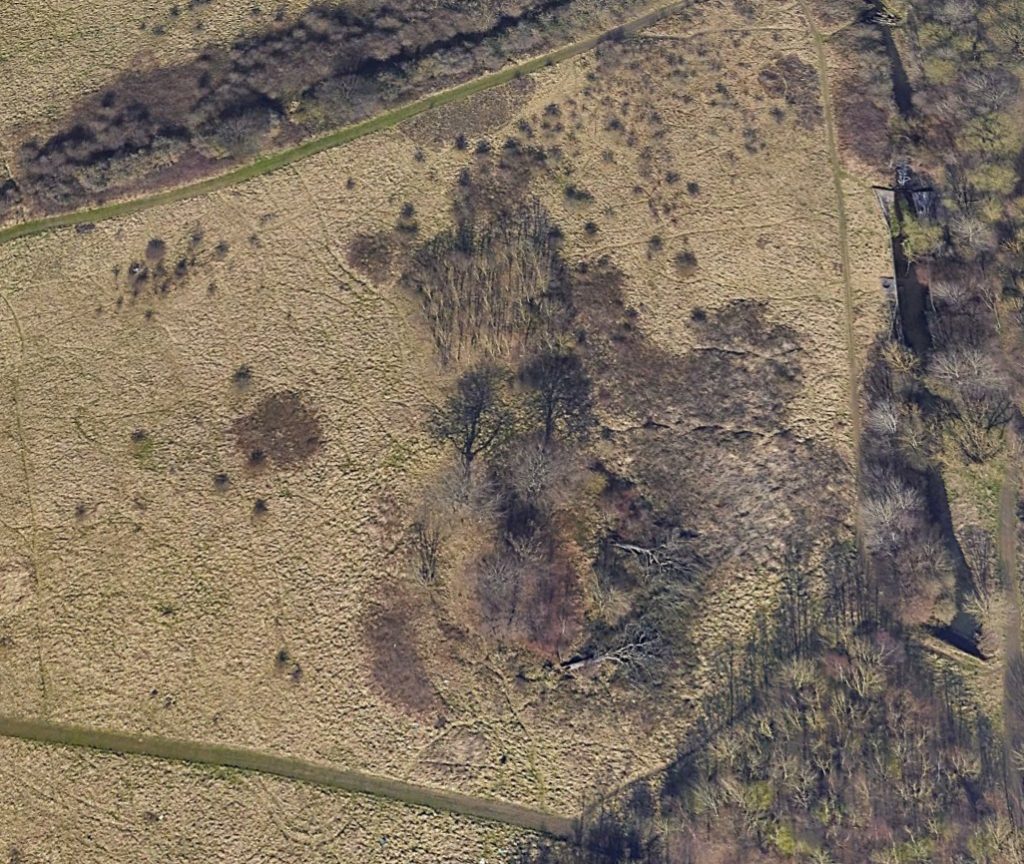
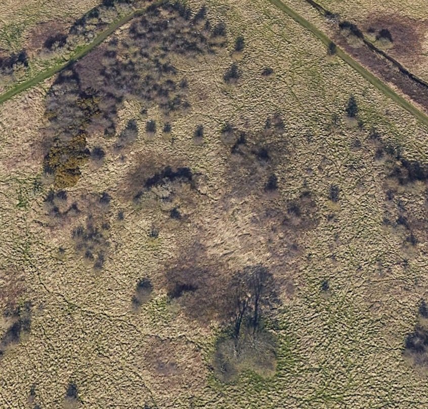
It is my subsequent theory, using this open source material of historic ONS maps and LIDAR technology, that Foxy Island could be home to a yet undiscovered prehistoric barrow, similar to those seen in Burdon, and perhaps a former medieval building too. Foxy Island is a unique position that it is one of the open spaces in Sunderland that has never been developed, even as the area around it has been. Because of this, the area has never ever been subject to any archaeological searches or findings. Instead, it has been part of a broader estate for centuries and if it was used as farmland long ago, it isn’t now.
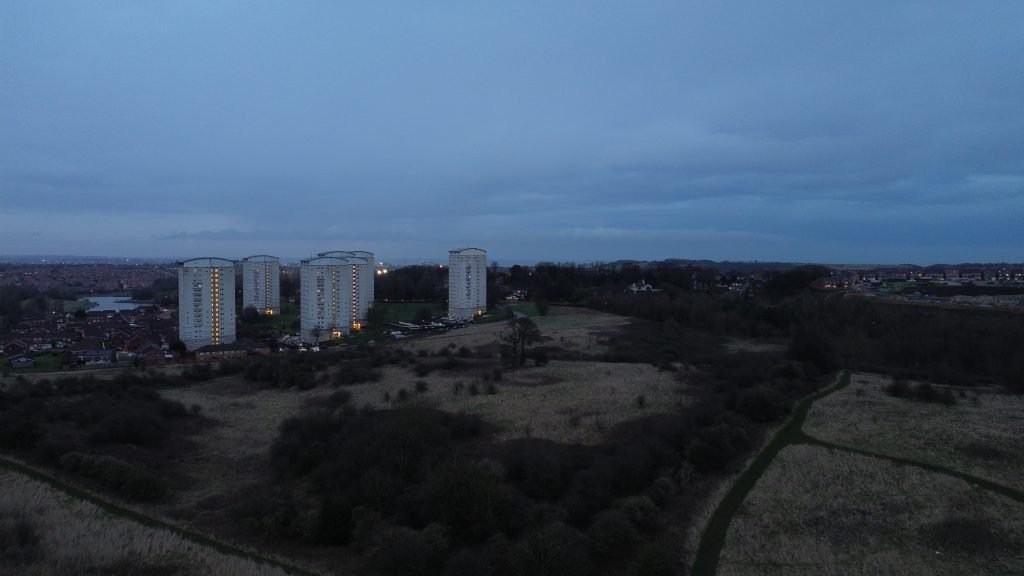
But, as the maps and LIDAR details show, there were two specific parts of this land that could not be used and thus “marked off” on maps due to having unusual features. If similar places are anything to go by, such as in Hangman’s Lane, Warden Law, Seven Sisters, on Copt Hill, Humbledon Hill or Hasting Hill, then it is possible the top of Foxy Island is a barrow, with trees planted on it that has been lost to time and with the land never being used for anything, nobody ever cared to look. Well that changes now.